Technologies

Wagtail / CodeRed Extensions
Content Management System
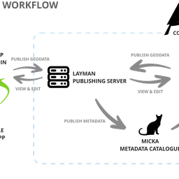
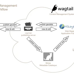
Editorial system represents a basic unifying element for geodata processing. This system is able to create a web portal and also represents a natural junction for other parts of the system. The editing system solution is based on Wagtail CMS (Content Management System) Platform, extended by CodeRed Extensions. It is one of the leading open source CMS used by small as well as large organizations (Google, NASA, British NHS). Wagtail is based on the Django system and its main programming language is Python. It enables a very easy extension of the functionalities in a forms of widgets, web page templates, or extending of authorization and other system parameters. It is therefore possible to integrate it with other systems used within the organization (e.g. geoportal of a city), if such demand occurs. There is a huge community of developers behind the system, where more complements and extensions can be developed.
HSLayers-NG
Map application
The web mapping component uses the open source mapping framework HSLayers-NG, see https://ng.hslayers.org/. This tool has been developed for a long time. It enables significant customization or functional additions depending on the requirements of the system. At the same time, there is already a functional integration to the Wagtail CMS in the form of a map widget, which will allow easy creation of maps within all HTML pages of the content management system, including detailed configuration of map layers and tools if required.
Layman
Publishing server
Layman is a web service for publishing geospatial data online through a REST API. It accepts both vector and raster data in GeoJSON, ShapeFile, GeoTIFF, JPEG2000 and other formats together with visual styling and makes it accessible through standardized OGC APIs: Web Map Service, Web Feature Service, and Catalogue Service. Even large data files can be easily published thanks to chunk upload and asynchronous processing.
Map Compositions
JSON map definition schema
JSON based format for sharing and storing maps. Used in HSLayers-NG and Layman to describe parameters for constructing OpenLayers objects and map properties such as viewport, layers, author and other metadata. It was originally inspired by OGC Web Map Context and OWS Context.
Open Micka
Metadata Catalogue
Detailed metadata catalogue with INSPIRE standard support. All geodata published by our tools is automatically metadata-recorded. The metadata can be searched back through the HSLayers web client or the QGIS desktop tool.
QGIS
Desktop GIS
The Leading Open Source Desktop GIS. QGIS is a professional GIS application that is built on top of and proud to be itself Free and Open Source Software (FOSS).
Our QGIS Layman plugin allows anyone to manage geodata, publish layers as OGC WMS and WFS or create whole maps while preserving the symbology.

QField
Mobile GIS
Survey and digitise data in no time. QField is the professional mobile app for QGIS, allowing users to deploy their existing projects to the field.
We are working on the foundation of the QField and building apps aimed at real world use cases.